
The good.
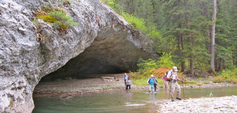
Last September my wife and I participated in a group-hike in the Little Belt Mountains east of Great Falls – roughly 40 miles SW of the geographic center of Montana. It was a long drive for a day-hike (over 175 miles from Helena to the trailhead), but we’d heard great things about this particular walk. The 13-mile hike, which is one of dozens offered every year by the Montana Wilderness Association (MWA), lived up to its billing. By far, the highlight of the day was walking through Arch Coulee and a spectacular limestone canyon carved by the Middle Fork of the Judith River – along a route that included over 15 stream crossings. (Photo Tour of the Hike)
The bad.
According to their mission statement, the MWA “works with communities to protect Montana’s wilderness heritage, quiet beauty and outdoors traditions, now and for future generations”. So, the leaders of their hikes try to help participants understand some of the challenges the MWA faces. Noel Birkland of Lewistown, who led our hike, gave us a first-hand look at how human activity has damaged the Middle Fork. Birkland explained that the Middle Fork used to be an excellent fishery – as good as any trout stream in Montana. He also showed us how motorized vehicles (Jeeps, four-wheelers, motorcycles) have changed that over the past several decades by stirring up silt and causing severe stream-bank erosion. During our hike through the canyon, we encountered 3 groups of motorized vehicles, including two groups on ATVs and another individual on a dirt bike – all friendly people. But the damage done by decades of folks crossing the stream on motorized vehicles was very convincing – I don’t mind sharing certain trails with responsible ORV drivers, but the Middle Fork is no place for motorized traffic! For more about this issue please go to the MWA’s page here.
And the ugly.
I would rate this 13-mile hike as moderate – as long as you do it on a nice day with favorable stream flows. There was hardly any elevation change and it was quite pleasant walking through the water on a warm September day. Wait until late summer, and pack your water sandals. We put them on at our lunch spot (see link to map below), and wore them for the last 3 miles of the hike. The trail is not well-marked, so you need to know the route before you go – Or better yet, sign up to go with the MWA next time they offer the walk. For this one the MWA leaders meet their hikers in Utica, and then car-pool to the trailhead. Whether you go with the group or go it alone, be sure to stop at the Oxen Yoke in Utica afterwards for one of their amazing “Ugly Burgers” – You’ll be glad you did!
- Photo Tour of the Hike
Over 15 stream crossings – bring water sandals! - Interactive Topo Map of the Area with our route marked.
Zoom in or out. - The Montana Wilderness Association
Keep it wild! - A Quiet Day in Utica
One of my favorite Charlie Russell paintings. - MWA blog post about issues with the Middle Fork
Its complicated.
Below: This map marks hikes that have been featured on bigskywalker.com so far – Select full screen to expand, zoom in for more detail or click on a marker for a link to the post.

Awesome review and pictures. Would love to do this….do you have the right information on who to contact for the group hikes? We want to go exactly to these places 🙂 wow!! Beautiful!!! Thanks for sharing….
LikeLiked by 1 person
Here is a link to information about how to sign up for a hike. Happy trails!
http://wildmontana.org/discover-the-wild/join-a-hike/2017-wilderness-walks
LikeLike
The water seems high for September but it can vary a lot in that area. Good photos, thanks for sharing them.
LikeLiked by 1 person
Sorry I missed some of your posts. I thought I was signed up to follow, but I guess not (now I am). Anyway, this sounds like a nice hike. Too bad about the environmental damage.
LikeLiked by 1 person
I have been exploring for a little bit for any high quality articles or blog posts on this kind of area . Exploring in Yahoo I at last stumbled upon this site. Reading this information So i happy to convey that I have a very good uncanny feeling I discovered just what I needed. I most certainly will make sure to do not forget this site and give it a look regularly.
LikeLike