

Haggin has a “presence”.
A couple friends and I took advantage of a perfect summer day to climb Mt. Haggin near Anaconda this past Tuesday. At 10,793 feet, West Goat Peak is the tallest in the Anaconda Range (aka “the Pintlers”), but Haggin (10,607 ft.) gets much more attention because it forms the backdrop for the city of Anaconda, plus it can be seen from miles away by those who drive I-90 through the Upper Clark Fork Valley. (Photo Tour)
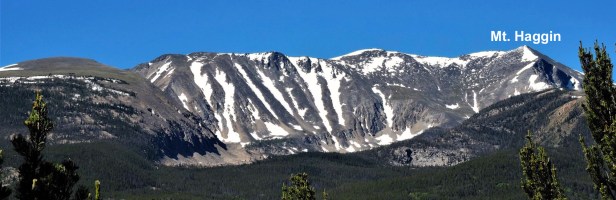
Photo courtesy of Dan Haffey.
A pleasant surprise.
Haggin caught my eye while I was in the Anaconda area for a wedding earlier this month. After two months of hiking at lower elevations, I was anxious to get up into the high country – And I was able to convince a couple friends Mark and Josh, both veterans of Mt. Rainier, to join me. Our biggest concern was the possibility of encountering lots of deep soft snow. At 16 miles round-trip with over 5,100 feet of elevation gain, the hike is already very difficult, so trudging through stretches of snow would have made the hike too much for us. As it turns out, snow was not an issue! What few patches we came across were firmed up, so we didn’t have to endure exhausting stretches of post-holing. Our two biggest challenges were a handful of stream crossings, and hiking the last 2 very steep miles from Hearst Lake up to the summit (2,350 ft. of gain).
If you go.
We parked at the Church of Christ on the western edge of Anaconda and started hiking at 7:30 am, relying on directions found on Summitpost.org (link below). The first six miles from the church to Hearst Lake are on an old road (foot traffic only) – It is pleasant, but nothing to write home about. Some of the more difficult crossings were actually places where heavy spring runoff was flowing across the road (shouldn’t be a problem later in the summer). From the lake to the summit, there is a faint trail – So faint that we were only able to find it periodically during our ascent. I’ve included maps and images in the photo tour that will help find it, should you decide to climb Haggin. It is a “very difficult” hike by my standards, but worthwhile if you’re up to it. The view from the summit was outstanding! We got back to the car at 4:30 pm, then stopped by “Smelter City Brewing” for an excellent “Road to Wisdom IPA” before making the 80-mile drive back to Helena.
- Photo Tour Our Hike to the summit of Mt. Haggin.
Sixteen miles with over 5,200 ft. of gain. - Map of the area we hiked.
Anaconda in upper right, Haggin in lower left. - Summitpost.org says it’s 14.4 miles round-trip
Our device said it was 16 miles – Not sure why the discrepancy.
Below: This map marks hikes that have been featured on bigskywalker.com so far, including several in Glacier Park – Select full screen to expand, zoom in for more detail, or click on a marker for a link to the post.

I grew up in Anaconda and made this climb sometime around 1983 ( I was 13). I would love to get back home and make the trip again.
LikeLiked by 1 person
This was awesome. Thank you for sharing
It. I’m trying to get a few friends do the hike. I don’t want to do it by myself ,,but that might be how it’s going to go
Thank you again, Don
LikeLike