
Into the bull’s eye.
Although I’m not a geologist, I enjoy learning as much as I can about the geologic setting of north-central Montana where I teach. I like to explore the landscape to get a first-hand look, then use photographs, maps, and other images to help students understand why the land looks the way it does. Google Earth has been a great tool, giving my students and I a bird’s eye view of landforms around us. A few years ago, while looking around on Google Earth, I noticed a strange circular feature on BLM land 10 miles south of Hays. The satellite view showed a distinct series of concentric circles, resembling a big target a few miles across. Interestingly, the target shape of the landform is not noticeable from the ground – only from above. A little research helped me understand how it was formed, but it wasn’t until recently that I ventured down there a couple times to explore it.
Got domes?
The strange feature is an “igneous dome”, caused by magma forcing layers of sedimentary rock upward tens of millions of years ago. The magma never made it to the surface, instead hardening below the layers. In the millions of years that followed the dome has eroded, leaving the concentric circular ridges of rock. Don’t get it? – The diagrams and maps in the photo tour should help. As it turns out, there are several domes in the area, all created by plumes of ancient magma that pushed layers of rock upward – each one is unique. In fact the Little Rocky Mountains north of the isolated domes were formed by magma that intruded there about 50-55 million years ago. For more about that, see my blog post titled “Wall Walk in the Little Rockies”.
First try.
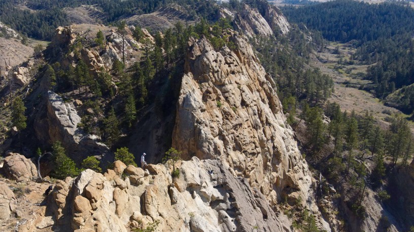
My friend Rick accompanied me on the first hike into the dome on August 25th. I didn’t plan a very good route and we didn’t carry enough water, so we didn’t get to explore much of the dome. I also underestimated how difficult it would be to hike up and down those concentric ridges. Fortunately, our walk back took us below the impressive sandstone cliffs on the southern edge of the dome. We took a nice break there while I took some drone photos and thought about a better route for my next trip.
Take Two.
Although Rick wasn’t available for a second trip on September 15th, I was better prepared – I planned a more sensible route, ate my Wheaties, got an earlier start, and carried plenty of water. This time I walked along Bull Creek much of the way, veering off to do a clockwise loop near the north end of BLM land and then again to explore the cliffs on the south end before exiting the dome. Bull Creek meanders north to south right through the center of the dome. Hiking along the dry creek bed was easy but I felt like I was missing out on views, plus there was some mud and a few cows. On the way back I scrambled up a ridge to a nice grassy bench, and then walked over to explore the sandstone cliffs, by far the best part of my day. The hike, which ended up being 12.3 miles, took 8 hours, mainly because I spent so much time exploring those gorgeous cliffs.
FYI – I recently started an Instagram account. I will try to post something interesting at least once a week. Check it out: rodbenson406
- Photo tour of two trips into the dome.
Includes maps of my route, more details about the hike. - Relive animation of the second half of my hike.
Does not include the “out” – only the “back”.
Below: This map marks hikes that have been featured on bigskywalker.com so far, including several in Glacier Park – Select full screen to expand, zoom in for more detail, or click on a marker for a link to the post.

Big Sky Walker,
<
div dir=”ltr”>Thank you sooo much for taking us along
LikeLike
Another wonderful write up! Thanks for sharing!
Weston Kellogg Conrad, MT 406-450-5438
LikeLike
Very interesting! Thank you for sharing!
LikeLike