
Top of the line.
Over the past several years, I’ve hiked over 300 miles in Glacier Park – Many of those miles were walked during back-country trips, or while doing off-trail hikes and climbs, but I’ve also rubbed elbows with thousands of tourists along most of the popular trails in the park. Although hiking on maintained trails is not as exciting as getting above the trees and away from the crowds, there is one trail that offers views comparable to any you will see while back-packing or peak-bagging in the park – It’s called The Highline Trail. But don’t take my word for it. Jake Bramante, who in 2011 became the first person to hike all 734 miles of trail in Glacier Park in one year, ranks the Highline Trail #1 on his list of favorite day-hikes in Glacier Park.
Alpine time.
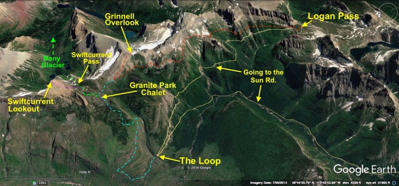
What sets the Highline apart is that it is an “all-alpine route” that wanders high above the Going to the Sun Road, and just below one of the most spectacular parts of the Continental Divide (The Garden Wall). Walks with views like this usually demand that you do some steep, off-trail hiking and scrambling to earn time above the trees. That’s not the case here – In fact, the trail between Logan Pass and Granite Park Chalet (7.6 miles) gradually gains less than 700 feet! (Add another 950 feet if you take the .8-mile spur to the Grinnell Overlook.) As for the views – To see what all the fuss is about, look through the Photo Tour.
To loop, or not to loop.
The most popular way to do the Highline is to start at Logan Pass, hike to the Granite Park Chalet, and then descend to a place on the Going to the Sun Road called “The Loop”. According to Jake’s “Day Hikes of Glacier National Park Map Guide“, this is an 11.4-mile trek with 1,300 feet of gain and 3,700 feet of loss. However, I don’t like to do it this way. As much as I love the Highline Trail, I’m not crazy about the stretch from Granite Park Chalet to The Loop. It’s a downhill slog through an area that burned in 2003, and quite frankly the views aren’t as nearly as grand as those between Logan Pass and the Granite Park Chalet.
I’ll take the high road.
Instead, I prefer to hike from Logan Pass toward the Granite Park Chalet with the morning Sun at my back, and then return on the same trail with the afternoon Sun at my back. The scenery is so fantastic that I like to enjoy it from both perspectives, and in different lighting conditions. Of course it’s a longer walk – 15.2 miles from Logan Pass to Granite Park Chalet and back. If you take the spur up to the Grinnell Overlook, that adds another 1.6 miles (round-trip). When my wife and I last did the hike, we took the steep side-trip up to the overlook, and skipped the last .8-mile stretch to the Granite Park Chalet. So our hike also ended up being about 15.2 miles round-trip. The chalet is pretty dang cool, but given a choice, I’d rather look down on the cirque carved by the Grinnell Glacier. NOTE: There are a couple other options from the Highline Trail, which I explain with a map included in the Photo Tour.
FYI – links, trivia, insights, etc.
1. Photo Tour – A picture is worth a thousand words. Click here to see photos, maps, etc. Be sure to read the captions.
2. The Guru – If you plan to do any hiking in the park, I highly recommend Day Hikes of Glacier National Park Map Guide by Jake Bramante. It is a beautiful, packable map of all the park’s trails with all sorts of helpful information.
3. Rating – To hike out-and-back from Logan Pass to the Grinnell Overlook (without walking all the way to Granite Park Chalet) is “difficult” in my book (15.2 miles round-trip).
4. Must see! – Whatever route you choose, you really do need to do the extra 1.6-mile round-trip hike to the Grinnell Overlook. The view is special.
5. Logistics – If you plan to start at Logan Pass and end at The Loop (the most common way to do the Highline), park at the Apgar Visitor Center (near Lake McDonald), ride a shuttle bus to Logan Pass, do the hike, and then catch a shuttle bus at The Loop for a ride back to Apgar. If you plan to do an out-and-back (which I prefer), get an early start – drive to Logan Pass at sunrise and park there. It can be difficult to find a parking spot at Logan Pass if you arrive too late in the morning, especially in July and August – Some days the parking lot is full by 8 am!
6. Shuttle Service – Leave the driving to someone else, and enjoy the view. Click here for details.
7. Topo Map – To see an interactive map of the Highline area, take a look at this CalTop.com map. Once the site opens, you can zoom in or out, or drag the map to see a different area.
8. August 13, 1967 – During The Night of the Grizzlies a 19-year-old woman was killed by a bear near the Granite Park Chalet. That same night, a different bear killed another 19-year-old woman in a different part of the park. These were the first fatal grizzly bear attacks ever recorded in the history of the park.
Below: This map marks hikes that have been featured on bigskywalker.com so far – Select full screen to expand, zoom in for more detail, or click on a marker for a link to the post.

Thank you beautiful and well done
Sent from my iPad
LikeLike
My favorite too: here’s how I like to do it- Logan Pass to Granite Park Chalet, hitting the overlooks. Then up to Swiftcurrent Pass & up to the lookout then down into Many Glacier. Haven’t been back in 20 years – I think it’s time to go!
LikeLiked by 1 person
That’s about 20 miles – but a great hike if you’re up to it.
LikeLike
Yes – If you’re up to it (and can do the shuttle) that is the perfect way to do it. With those side-trips you included the hike ends up being 20 miles.
LikeLike
Ahh, this might still be a stretch for us, but I’d really like to do this hike. The shuttle will no longer be an option when we are there in September. Thanks for the tip on the out and back and all the helpful resources. I don’t want to click on “The Night of the Grizzlies. Great post…it’s going in my file.
LikeLike
I’ve seen some of the hikes you’ve done. You could do this one.
LikeLiked by 1 person
Yes – That’s a big reason why Logan Pass is so busy. I featured the Highline Trail on my blog this past March. Here is the link: https://bigskywalker.com/2017/03/12/the-highline-best-trail-in-glacier-park/
LikeLike
While Jake is a good resource for day hiking. Joey Coconato has spent more time in the park than anyone on the planet…has stayed at every backcountry site and hiked hundreds of off-trail miles (not including every single mile of trailed hikes) multiple times. All the backcountry rangers know him and will at times refer hikers to him. The guy spends over 250 nights a year in his tent.
Take care,
CTM
LikeLiked by 1 person
PS: For my money the best part of the Highline Trail is from Granite Park to Fifty Mountain. Peace.
LikeLiked by 2 people