
Helena is great “base camp”.
One of the nearby places that I’ve become especially fond of over the past two summers is a 50-mile stretch of The Rocky Mountain Front located 80-130 miles north of Helena. I’ve done over a dozen “day-hikes” in this area – several with friends, a few with my wife, and a couple by myself. It’s close enough that I can leave Helena early, make the drive, enjoy a nice hike, and be home before the Sun sets – It makes for a long day, but it’s a long, GOOD day. Many adventures from this area will be featured on this blog over the next few years, but this time I’d like to tell you about a couple hikes that both start at the same trailhead along the Sun River, about 20 miles northwest of Augusta.
Castle Reef Hike – an extraordinary ridge hike.
The entrance to the Sun Canyon is impressive (see photo above). Flanked by the iconic Sawtooth Ridge to its south and Castle Reef to the north, this is one of the prettiest places on the Front. On July 29, 2015 my young friend Atticus and I left Helena at 6 am, drove north 80 miles to Augusta then followed the Sun Canyon Road for 20 miles to the trailhead (just inside the canyon – see bottom of this page for directions). We hiked the short trail into Wagner Basin before scrambling up to an obvious saddle below a castle-shaped limestone pinnacle. From there we skirted the west side of this “castle” and then scrambled up to the ridge, working our way to the false summit and then onto the true summit where we lunched. I’m partial to ridge-walks, but this one was especially fun – It featured varied terrain, some route-finding, a little class 3 climbing, abundant fossils, interesting shaped sub-peaks, and one cool natural bridge. The hike ended up being 9 miles round-trip with 3,730 ft. of elevation gain. (Castle Reef Photo tour)
Wagner Basin – I got to count this one as a date.
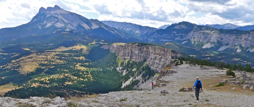
Earlier that same month, my wife (Mardi) and I (and our dog Missy) did a much easier hike that took us through Wagner Basin to the cliffs on the eastern edge of the basin. We started a the same trailhead, followed the short trail until it petered out, and then picked a reasonable route that took us northward, up through a fairly open area. Eventually we turned east, crossing over a gulch and continuing up to the cliffs shown in the photo above. Mardi, Missy, and I followed the edge of the cliff as far as we could to a point that provided great views of the canyon entrance and the Sun River below. We decided to do a loop, rather than simply go back the same way. This hike was 4-5 miles with 1,000 feet elevation gain. (Wagner Basin Photo Tour)
I’ve gotten my money’s worth out of this book.
If you aspire to do any hiking along the Rocky Mountain Front, you really do need to buy the book titled Discover the Rocky Mountain Front by Tom Kotynski. Tom and his friends have decades of hiking experience in this area. The book features 32 adventures in the Front area – I have used the book to do variations of 13 of them. Tom’s book provides directions to trailheads, photos, insights, etc. He has also blogged for several years – His “Out there with Tom” is another great resource for those interested in hiking west-central Montana. In fact one of the reasons I started this blog is that I know how much his blog inspired me to get “out there”. Coincidentally, his most recent post was about a spring hike into Wagner Basin. I guess great minds think alike! 😉
Click on the links below to learn more.
- Photo Tour of the Castle Reef Hike
A difficult off-trail hike along a spectacular ridge. - Photo Tour for the Wagner Basin Hike
A moderate off-trail hike. - Photos from my second hike to Castle Reef
June 2017 - Interactive Topo Map of the Area
Zoom in or out. - Read about the Rocky Mountain Front Heritage Act
Montana Wilderness Association - What exactly is the “Rocky Mountain Front?
The answer to that questions depends on where you live. For those who live in Montana, it is the general area that extends from the Rogers Pass-Augusta area north to the southern boundary of Glacier Park. This loosely defined transitional area is where the mountains abruptly end and the great plains begin, including the eastern part of those mountains and the western part of the prairie.
Directions to the Wagner Basin Trailhead
Source: “Discover the Rocky Mountain Front” by Tom Kotynski – From Augusta, follow the Sun Canyon Road #108 for 18 miles. Turn west on Hannan Gulch Road #8383, cross the bridge over the Sun River and travel approximately 1/4 mile to the second road heading east on the right. Turn right and continue to the end of the road, passing several summer cabins along the way. Parking is available for several vehicles at the trailhead. No outhouses or other facilities are available.

The ridge at Castle Reef looks absolutely stunning. Your photo tour and details are excellent.
LikeLiked by 1 person