

So many mountains, so little time.
I’m not a “type A” peakbagger, but I’ll admit that I pay attention to peak elevation, and I do enjoy that extra sense of satisfaction that comes with reaching a summit that is over 10,000 feet tall. According to information on our state’s website, Montana has 244 such mountains – and all of them, except for seven in the Crazies north of Big Timber and six in Glacier Park, are located south of I-90 in the southcentral and southwestern part of the state. The highest 41 peaks in the state are in the Beartooth Mountains, including Granite Peak, our state’s tallest mountain at 12,799 ft. (Source: Montana.gov)
No gravel? No bush-whacking?
Although Mount Blackmore (10,154 ft.) south of Bozeman only ranks #202 on the list, it may win the prize as Montana’s “most accessible summit over 10,000 feet”. The 15-mile road from Bozeman to the trailhead is paved, and a nicely designed 6.5-mile trail leads all the way to the summit. There is absolutely no bush-whacking, scrambling, or scree to contend with, which is VERY unusual for a mountain over 10,000 ft. tall. The “trail all the way to the summit” part was a big selling point in convincing my friend Kacey and his daughter Alex to make the 115-mile trip from Helena to climb Blackmore this past Monday (7/9/18) – As for me, the “paved all the way to the trailhead” part was appealing, especially after doing a couple recent hikes that required lengthy drives on rough gravel roads. (Photo Tour)
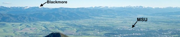 I think I have labelled this photo correctly, but correct me if I’m wrong.
Trip report.
We left Helena at 6 am, started hiking at 8:30, and completed the 13-mile (round-trip) hike at about 3 pm. Blackmore seemed busy for a Monday. We encountered about 15 other hikers, ranging in age from pre-teen to late 60’s – mostly folks going up as we were coming down. I shouldn’t have been surprised – Besides being so accessible, especially for those who live in Bozeman, it is a very pleasant hike despite the 3,434 ft. gain in elevation. For the first 4 miles, the well-signed trail climbs gradually through a forested area along the lower part of Blackmore Creek, passing Blackmore Lake at the 3-mile mark. Around the 4-mile mark the trail gradually climbs out of the forest, switch-backing up the scenic south end of the valley. It was all good, but the last 2.5 miles of the hike were especially enjoyable – I REALLY like the openness of that part of the trail, which gave us amazing views during our final hour of hiking to the summit. The only flaw on this particular day was that smoke from wild fires in other states had drifted into the area, making it difficult to see the Bridgers and other more distant ranges. On the bright side, the wildflowers were incredible, we had a nice visit with a delightful retired couple on the summit, and our views of the immediate area weren’t too shabby.
- Photo Tour of Our Hike to the summit of Mount Blackmore.
Thirteen miles round-trip. - Map of the area we hiked.
Zoom in or out, scroll around.
Below: This map marks hikes that have been featured on bigskywalker.com so far, including several in Glacier Park – Select full screen to expand, zoom in for more detail, or click on a marker for a link to the post.

I hiked Mt. Blackmore last year, and it was lovely but the smoke was seriously oppressive until about 9000 ft, when we finally broke through! We also picked an incredibly hot day to do it, so while I appreciate the openness of the last two miles of the hike, it was quite warm. Unsurprisingly, the peak was crowded when we got up there- standard for any peak in MT in the summertime!
LikeLike