
Plenty of options.
The Pine Creek Trail 15 miles south of Livingston has something for everyone. Hikers can choose to do an easy 1.2 mile walk to Pine Creek Falls, a more strenuous 5.5-mile hike to Pine Creek Lake, or a very challenging 7-mile trek to the summit of Black Mountain, which involves a mile of elevation gain. A week ago (8/11/18), our friend Christie invited my wife and I to hike to the lake, and then this past Thursday (8/16/18) I returned to climb Black Mountain.
As easy as it gets . . . Pine Creek Falls
The 1.2-mile hike to Pine Creek Falls is a great one for families with young children (Grotto Falls 20 miles south of Bozeman is another). The path only gains 300 feet of elevation on its way to the base of Pine Creek Falls, where you can cross a sturdy bridge, and then just sit in the shade and enjoy the impressive falls. If you go, expect plenty of company – This is a VERY popular hike. For more of an adventure (not recommended for children), continue on the trail, which switch-backs to a ledge above the falls. It’s an interesting, but dangerous vantage point, so be careful. Waterfalls kill more people than grizzlies do – one miss-step and you’re a goner!
Some beach . . . Pine Creek Lake
After the falls, the trail steepens significantly, gaining 3,200 feet during the next 4 miles to Pine Creek Lake. I’ve done more difficult 11-mile (round-trip) hikes, but this might be the most challenging one I’ve done on an actual trail. Get an early start, especially if it is going to be a hot day – and take a water filter, so you don’t have to pack so much water. Those who can’t make it to the lake, should shoot for the gorgeous waterfall that cascades over an outcropping of white rock 3.7 miles from the trailhead. If you do make it all the way to Pine Creek Lake, you will be treated to one of the most scenic and unique beaches in the state. All total, the hike up and back to the rock-solid beach at Pine Creek Lake is 11-miles with 3,500 ft. of elevation gain.
 Black Mountain as viewed from Livingston (26 miles east of Bozeman).
Above and beyond . . . Black Mountain.
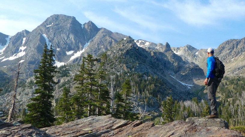
Those who want even more can hike another 1.5 miles to the summit of Black Mountain, which stands 1,900 feet above Pine Creek Lake. It’s a difficult off-trail hike that took me an hour and a half to complete on 8/16/18, but there is no technical climbing involved. The trickiest part is negotiating the scree to get around the false summit – a stretch that took less than 15 minutes (not dangerous, but not fun either). The summit features a pleasant combination of rocky cliffs and gentle grassy slopes. I spent an hour there, looking around and enjoying the warm, sunny, calm conditions. The only downside is that the skies were too hazy to see distant ranges such as the Crazies and the Bridgers. However, I did get to see an interesting layered appearance in the atmosphere to the west (above the Paradise Valley). The boundary between the smoky lower layer and the clear air above was very distinct, similar to what we see in the Helena Valley during our winter temperature inversions. (Photo Tour)
Got cheese-steak? . . . Trip summary
I left Helena at 4 pm on Wednesday, drove to Livingston (123 miles), ate a “cheese-steak sandwich” at the Pickle Barrel, drove 15 miles to the Pine Creek Campground, slept there, rose at 6 am Thursday, and started hiking at 7 am. I reached Pine Creek Lake shortly after 9 am, took a short break, went off-trail near Jewell Lake (see photo tour) to hike to the summit, arriving there at 11 am. After spending an hour on top, I took my time hiking back to the trailhead, getting back to my car at 4:30 pm. The hike ended up being 14.5 miles (included short side-trip to unnamed lake, wandering on summit, etc.) with ~5,200 of elevation gain. I was home by 7:30 Thursday evening.
Getting started . . . Directions to trailhead
From Livingston follow U.S. Highway 89 south into the Paradise Valley along the Yellowstone River for 2.9 miles. Turn left on East River Road and drive 7.8 miles. Turn left on Pine Creek Road, which winds another 2.7 miles up a forested hillside to Pine Creek Campground and trailhead.
- Photo Tour of the Pine Creek Trail.
Includes two hikes – 8/11 to the lake and 8/16 to Black Mtn. - Map of the Pine Creek area south of Livingston.
Zoom in or out, scroll, drag, etc.
Below: This map marks hikes that have been featured on bigskywalker.com so far, including several in Glacier Park – Select full screen to expand, zoom in for more detail, or click on a marker for a link to the post.

Another impressive hike in Montana! You really live in a wonderful spot. It’s great that this hike offers so many options. The lakes are incredible beautiful. It looks like your skies are not as smokey as ours in BC (not a lot of views these days).
LikeLike
Thanks, Caroline. Unfortunately the smoke has moved in since i did this hike. This morning in Helena, visibility was about 1 mile – Takes a lot of the fun out of peak-bagging!
LikeLike