
Close to home.
I started my 37th and final year of teaching a couple weeks ago, so I haven’t been on any interesting adventures for a while – time and energy have been in short supply. However, this past Sunday (9/9/18) several friends and I got together for a hike to the summit of Red Mountain, a prominent peak located 12 miles southwest of Helena (as the crow flies).
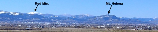 Above: The horizon to the right of Mt. Helena is a portion of the Continental Divide.
A Helena classic.
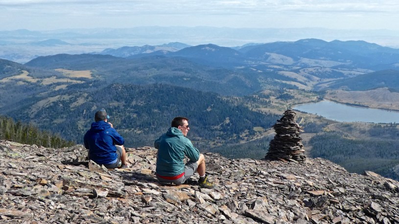
The hike to Red Mountain (elevation 8,150) is one of the great “close to home” hikes for those of us who live in Helena (trailhead is only 20 miles from town), so I was a bit surprised that six of the nine people in the group had not climbed it before. During the short, steep hike, you gain 1,700 feet of elevation and walk about 4.5 miles round-trip. It’s actually only 1.7 miles to the peak, but it’s fun to explore the perimeter of the broad summit and enjoy the views, especially from the north and east sides. Supposedly, on a clear day you can see 10 counties and 9 mountain ranges. (Photo Tour)
In the heart of Helena’s watershed.
Everyone who lives in Helena should know about the area that surrounds Red Mountain because this is the “Upper Ten Mile Watershed” – the primary source of water for the city of Helena! One of the most interesting things about hiking to the top of Red Mountain is seeing parts of the system devised by the City of Helena to collect and store the water. By far, the most fascinating component of this system is the aging 5-mile-long Red Mountain Flume – an old aqueduct that takes water from Banner Creek (near the trailhead) around the north side of the mountain to Chessman Reservoir. A portion of the flume can be seen (far below) as you look down from Red Mountain. After you return to the trailhead, I suggest that you walk (or drive) down the road .3 miles to the place where the road crosses the flume for a closer look. For more about the flume and other aspects of the system, check out the photo tour (be sure to read the captions). I’ve hiked along the Red Mountain Flume a couple times in recent years, so the album also includes several good photos of this important aqueduct.
So, what are you waiting for?
To reach the trailhead, drive to Rimini (17 miles from Helena, all paved) and then continue on the winding gravel road that takes you to the unmarked trail on the west side of Red Mountain. Start keeping track of the mileage at the southern edge of Rimini (some sort of concrete water works area surrounded by wire fence). Follow the road for 2.6 miles to a fork in the road: Go right, and follow the road for exactly 1 mile. There is a parking area on the right, and the trail starts on the left side of the road, several feet uphill from the parking area (no sign). For the first few hundred yards the trail follows a stream through dense vegetation. The middle portion of the hike is very steep – Some knees do not like coming back down through this part. The trail takes you to a ridge. Turn left at the ridge and follow the cairns to the top. Since the path is not an official trail it is not maintained, so you’ll have to climb over a few downed trees. As always, pack your bear spray and stay “bear aware”!
- Photo Tour of the Red Mountain hike.
Includes photos from my flume hikes as well. - Map of the Red Mountain area.
Zoom in or out, scroll, drag, etc.
Below: This map marks hikes that have been featured on bigskywalker.com so far, including several in Glacier Park – Select full screen to expand, zoom in for more detail, or click on a marker for a link to the post.

Thanks for posting this trip report! The picture of the map was perfect for finding the trail. There aren’t many reports on Red Mountain and the few that I found said there was no trail; one went on to say he tried every side of Red Mountain and couldn’t find a trail :). The trail does have some blowdown, not unexpected on an unsigned, unmaintained and on a trail that no map shows, but overall it’s in good shape. Definitely steep as you leave the drainage with nary a switchback, but worth the climb! It was also very interesting to learn about the nearby flume too, that was totally news to me. Thanks.
LikeLike
Moved here two years ago, and just discovered your blog. What a resource- thank you! You mentioned in the red mountain post that you’ve often just hiked the flumes. I didn’t see a separate post for that (sorry if I missed it). I’ve got visitors coming who might find the full mountain hike rough, but might like a shorter route including part of the flumes. Have you got tips for where to start such a hike? Thanks again.
LikeLike
I have not done a blog post about the flume hike. It’s not really a trail. The flume starts beneath the road, about three tenths of a mile downhill from where the Red Mountain trail begins. The flume is about 5 miles long.
LikeLike
Man. We went today and your directions worked great until the fork in the road 2.6 past the water area that’s fenced in. After turning right, we ended up in what appeared to be a construction site with lots of cars, a cabin and a heeler dog barking and chasing us away. I don’t know if someone’s bought a property on the road since you wrote this but, it was very intense and unwelcoming to say the least. We turned around and just did the 10 mile creek loop.
LikeLike
Did you go exactly 1 mile past the fork in the road?
LikeLike
According to my odometer. I’m going to scout it again soon on my motorcycle. If the weather permits. There is a compound near the fork and apparently someone bought a home and put connex boxes, has scattered automobiles and aggressive dogs running freely now.
It could be a mistake on my part somehow. Otherwise, your description and explanation of the area was real cool and interesting. Sorry for the delay.
Cheers!
LikeLike