

Update 7/3/23 – A couple friends and I hiked up Red Mountain today. I do not recommend the route described in this post. It is now extremely difficult to get up to the ridge due to deadfall, etc. Next time I climb Red Mountain I will try to hike in from Heart Lake.
One of my happy places.
The hike to the summit of Red Mountain is another outstanding “close to home” hike for those of us who live in Helena. It is both challenging and enjoyable, but the best thing about the hike is the view Red Mountain provides of the surrounding area. Any time you can look to the northwest and see the Mission Mountains near Missoula, and then turn northeast to see the Highwoods on the other side of Great Falls, you know you’re in a good place.
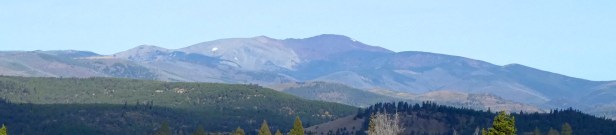
Above: Roadside view of Red Mountain (9,415 ft.) from Highway #279, a few miles north of Flesher Pass. FYI – There are MANY mountains in Montana named “Red Mountain”.
Window of opportunity.
The smoke that muddied our skies earlier this summer disappeared a few weeks ago, so I decided to climb Red Mountain before snow returns to the high country, which could be any day now. I convinced a couple friends (Mark and Murray) to go with me on Saturday, September 22, but unfortunately I led them up the wrong ridge – DANG! By the time I realized my mistake, we were too far away from the summit to make it up and back in a reasonable amount of time. It was a stupid mistake, especially considering that I had climbed it in 2014, but Mark and Murray were great sports. We hiked to the end of the ridge (boundary of the Scapegoat Wilderness), looped down to explore a couple old mines, and then stopped by a pretty little lake near the headwaters of Copper Creek. It ended up being an enjoyable 8.3-mile outing.
Take two!
As I was telling my daughter (Amy) about the blunder, it occurred to me that she might like to climb Red Mountain with me. She was willing, so I arranged to take a day off, and we set off to do the hike last Wednesday (9/26/18). We left Helena at 8 am, drove 67 miles to a locked gate near the end of Copper Creek Road north of Lincoln, and started walking at 9:40 am. The two of us (along with our dog Missy) hiked along the road for 1.4 miles beyond the gate, bush-whacked up to the correct ridge, and then followed it to the summit, arriving there at 12:50 pm. It was VERY windy, so we took shelter in a rocky bivouac, ate lunch, and enjoyed the view, spending a good chunk of time identifying the many distant mountain ranges we could see. Amazingly, I recognized at least a dozen other peaks I’ve climbed over the past decade. Another highlight was the herd of mountain goats that we watched below us as we hiked the barren ridge to the top. Any time you can look DOWN and see a herd of goats, you know you’re in a good place. (Photo Tour)
Free advice.
Amy, Missy and I enjoyed the day, but there are a couple things that would have made it even better (see #1 and #3 below).
1. Go in July or August, before the USFS closes the gate for the season. The locked gate near the end of Copper Creek road added almost 3 miles (round-trip) to our hike. The USFS closes the gate on September 1st and then opens it on July 1 the following summer. So, if you go in July or August you will be able to drive farther before starting to hike. Our walk ended up being 11.5 miles with about 3,500 ft. of gain (6.5 hours from start to finish). It would have been about 8.5 miles (5.5 hours) if the gate had been opened.
2. Save this hike for a clear day (we did). Don’t go if the skies are hazy as they often have been in recent summers. Remember, the best thing about this hike is the view of distant ranges.
3. Wait for a calm day (if there is such a thing on Red Mountain). We were ready for wind (layers, caps, gloves), but it definitely took some of the fun out of walking that beautiful ridge. The goats made up for it though.
4. Know the way. I’ve provided a link to a site below that shows the best route on a map that allows you to zoom in or out, or switch to a Google Earth view. It is a great resource for this hike (peakbagger.com). I’ve also included a map and images in the photo tour.
5. Get the Peakfinder app. You point your device toward distant mountains, and it labels them for you. (Peakfinder isn’t paying me for this endorsement, but they should be!)
6. Bring binoculars. I normally don’t, but it is worthwhile to bring them on this trip. Did I mention that you can see many mountains from this summit?
- Photo Tour of the Red Mountain hike.
Includes a map that shows the best route. - Map of the Red Mountain area.
Zoom in or out, scroll, drag, etc. - Peakbagger.com site with GPS track.
Great resource that shows the best route to the summit.
Below: This map marks hikes that have been featured on bigskywalker.com so far, including several in Glacier Park – Select full screen to expand, zoom in for more detail, or click on a marker for a link to the post.

Thank you for the tour!
LikeLiked by 1 person