
Picky, picky, picky.
I was hoping to walk from Rogers Pass northward to Lewis & Clark pass on CDT this past Sunday, but the phrase “strong winds” in the forecast swayed me to find a different place to take my first snowshoe hike of the season. My friend Mark and I decided to try a trail that loops through a portion of the Elkhorn Mountains 15 miles southeast of Helena. There, the forecast was much more to our liking – calm and sunny, with highs in the low 30’s.
Something old, and something new.
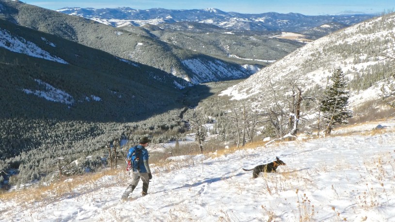
Mark and I are very familiar with the first 3-mile section of the trail, having followed it many times on hikes to Casey Peak. The trail, which starts at the confluence of McClellan Creek and its East Fork, gradually climbs through East Fork’s scenic valley to Casey Meadows. From there it veers off to the south and steepens for the final 2.5 miles to the summit of Casey Peak. However, this time Mark and I turned northeast at the meadows (A on map below) and followed the Montgomery Park Trail up to the pass between the East Fork and Jackson Creek watersheds. As we hiked to the pass, we enjoyed crystal-clear views of Casey Peak to the south and the East Fork drainage below. Then as we crossed over onto the Jackson Creek side, we were treated to views of the Helena Valley and surrounding mountains. After 1.5 miles on the Montgomery Park trail, we took a left (B) onto the Jackson Creek Trail, which follows the creek before heading up and over into the East Fork drainage. The 8.7-mile loop took 5 hours to complete.
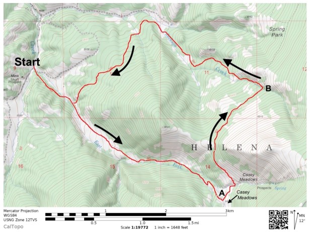 Above: We started at the Casey Meadows Trailhead – 14-miles from Helena via Montana City, or 17 if you go through East Helena. Map courtesy of Caltopo.com.
A nice walk in the neighborhood.
I wouldn’t classify this as an epic hike by any means – It’s not the kind of hike I’d drive 100 miles to do. On the other hand, it was a very pleasant outing, easy to reach from Helena, and one that I will definitely do again. If you go, choose a calm, sunny winter day with plenty of snow, and be sure to take a GPS device that shows the trail. On a couple occasions we strayed a bit off-trail, and had to refer to my device to get back on track. It’s hard to get lost, but the advantage of staying on the trail is that you avoid having to step over fallen trees, which are abundant here due to a fire that swept through in 1988. Watch for elk and moose, take a lunch break near the pass between East Fork and Jackson Creek, and enjoy the views!
- Photo Tour of our loop hike.
First snowshoe hike of the 2018-2019 season. - Map of East Fork and Jackson Creek area.
Zoom in or out. - Snowshoe hike to the summit of Casey Peak.
We did this one in December 2016. - Another blog post about snowshoeing in the Elkhorns.
From the winter of 2017-18. - Casey Meadows Trail.
Three miles one-way with 1,345 feet of gain.
Below: This map marks hikes that have been featured on bigskywalker.com so far, including several in Glacier Park – Select full screen to expand, zoom in for more detail, or click on a marker for a link to the post.

Cool!
LikeLike
Hi Rod: My son is coming home for Christmas break and he and a friend would really like to climb the nose of the Sleeping Giant during the break. Can you tell me if this is even possible? They are looking at 12/27 or 12.28, Thanks for the advice and have a Merry Christmas. Ellen Speranza
LikeLike
I think it would be dangerous to climb it in the winter, especially if it is below freezing. Has your son ever been up there before? The only way to get access without crossing private land would be to come in from the river, which could be cold and windy this time of year.
LikeLike