
Like a box of chocolates.
I’ve been wanting to snowshoe northward on Continental Divide Trail (CDT) from Rogers Pass to Lewis & Clark Pass and back for quite some time. I did the hike during the summer several years ago, but wasn’t sure I could make it that far on snowshoes – You never know what type of snow conditions you are going to encounter in the high country. Walking on the surface of of hard snow is easy, but when you’re sinking 2-3 feet into the soft stuff, every step is a struggle. Considering the huge amount of snow that has accumulated in our back yard (Helena), I wasn’t optimistic as I drove to Rogers Pass Sunday morning (3/10/19). But the Sun was shining and the forecast called for reasonable temperatures, so it was a good day to give it a go.
It’s a wind thing.
I parked at Rogers Pass, climbed a wall of plowed snow along the north side of the highway, strapped on my snowshoes, and started hiking at 8:30 am. Someone had been on the trail earlier in the week, so the first mile of switch-backs up to the Continental Divide was lightly packed – perfect for snowshoeing. Once on the ridge, snow conditions changed – But they were still decent. As the CDT turned me northward, I could see that strong winds had cleared the snow off many portions of the trail. I removed my snowshoes for a couple of those barren stretches, but spent much of the day snowshoeing on hard, drifted snow several feet east of the divide. The snowshoes were especially helpful as I walked up and down higher points along the trail. Although the snow was fairly deep in places, the surface was so hard that I didn’t sink in. Unfortunately, the same wind that created these favorable conditions was my constant companion, varying from 10-30 mph throughout the day. I wore a face-mask, ski goggles, and just the right number of layers to keep warm . . . as long as I kept moving.
Old Indian trick.
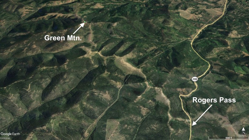
I didn’t quite make it to Lewis & Clark Pass. After 6.3 miles of hiking, I reached the summit of Green Mountain – high point on this section of the CDT, and a nice vantage point for admiring the pass. The significance of Lewis & Clark Pass is that this is where part of the Corps of Discovery crossed over as they returned from the Pacific in July of 1806. On their way back, the expedition split up near present-day Missoula. Clark’s group set out to explore what is now southern Montana, while Lewis took nine men to investigate this short cut over the mountains and then explore north-central Montana. The Corps learned of the pass from tribes west of the divide who used it to travel east of the mountains to hunt buffalo. Nez Perce men guided the explorers to the pass, but didn’t venture any farther due to concerns about encountering the Blackfeet. To learn more about Lewis & Clark Pass, take the photo tour – and be sure to read the captions. (Photo Tour)
Walk the line . . . or not.
Despite the wind, I enjoyed this 12.6-mile out and back walk along the CDT. However, a much easier way to access Lewis & Clark Pass is by way of a 1.5-mile hike that starts from Alice Creek Road west of the pass. To get there turn north onto Alice Creek Road (between Lincoln and Rogers Pass) and follow the gravel road for 11 miles to the trailhead (road is often impassible during winter). From there it’s a 1.5-mile walk up to the pass. For an extra 3-4 miles, turn right and follow the CDT to the summit of Green Mountain or turn left to climb Red Mountain a couple miles to the north. -Rod Benson
- Photo Tour of the Rogers Pass to Green Mountain hike.
Walking the Line – March 10, 2019. - Map of the CDT between Rogers Pass and Green Mtn.
Zoom in or out, scroll, drag, etc. - Lewis & Clark in Montana.
More about the return trip in 1806. - Hike along the CDT from Flesher Pass to Rogers Pass.
My blog post from October 2018.
Below: This map marks hikes that have been featured on bigskywalker.com so far, including several in Glacier Park – Select full screen to expand, zoom in for more detail, or click on a marker for a link to the post.
