
Prime time.
This July has been a great month for peakbagging in the Northern Rockies. The bulk of the snow has melted away from the peaks, and our views have not yet been hindered by smoke from wildfires. This past weekend, I took advantage of the window of opportunity to climb Mount Borah (officially “Borah Peak”), the highest mountain in Idaho. Borah had been on my RADAR for several years, but I really didn’t know much about it. I knew that it was about 8 miles round-trip with 5,500 feet of elevation gain (steep!), and that there was no technical climbing involved. As it turns out my ascent of Borah on 7/20/19 ended up being a GREAT peakbagging experience! – right up there with some of my best days of climbing in Montana.
Anticipation.
After my daughter and I finished a backpacking trip in western Washington (see previous blog post), we decided to swing through southern Idaho and climb Borah on our way back to Helena. As we drove into the traihead campsite Friday evening, reality set in as we were confronted with the steep, rocky ridges leading to Borah’s summit. I wasn’t sure if this was going to be a hike, or a climb! Fortunately, experience has shown me that those slopes often look more intimidating from a distance, so I was excited for the morning to come.
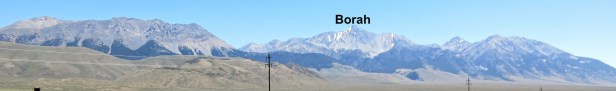
Above: View of the Lost River Range as we drove north to Salmon, ID.
The Eagle has landed.
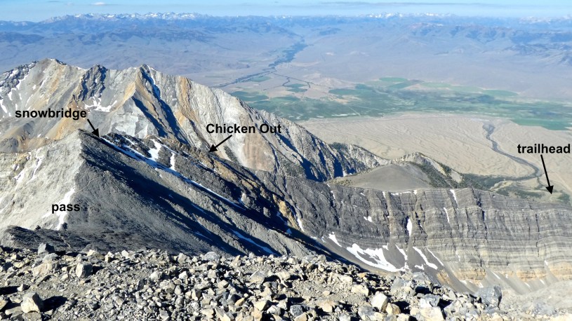
The night wasn’t especially restful – coyotes were howling at the almost full moon (which was pretty cool), and I heard several hikers starting between 3 and 3:40 am (impressive). Amy and I “slept in” until 4 am, ate breakfast, and started hiking at 5 am. About an hour into the hike Amy (a stronger hiker than I) got sick, and decided to return to the trailhead – Bummer! Fortunately everything else about the day was perfect. The weather was ideal, and I was very surprised at how fun the climb was. I especially enjoyed the variety of conditions encountered along the way to the summit – some were both physically and mentally challenging. The hike begins with a steep but well-trodden trail, followed by a climb up and along Chicken Out Ridge, a short sketchy walk across a snow-covered knife-edge ridge (the “snow bridge”), a path across a talus slope, a broad scenic pass, and the final long, steep scramble to the summit. I totally enjoyed 40 minutes of perfect summit-time on the 50th anniversary of the lunar landing. (Photo Tour)
In good company.
During the day I encountered about 30 hikers – some on my way up, and others as I was coming down. Watching hikers ahead of me negotiate the sketchy parts gave me confidence, and it was also fun to visit with folks who were out climbing such an impressive peak on a beautiful summer day.
Free advice.
1. Start early – 5 am was about right for me. I reached the summit at 9:30 am and got back to the trailhead at 1:10 pm, avoiding the heat of the day.
2. Wear boots, not running shoes – My 60 year-old feet are glad I did.
3. Know your skills – If you’re uncomfortable with exposure, this might not be enjoyable for you. From Chicken Out Ridge onto the summit you’ll be doing A LOT of scrambling (class 3).
4. Trim those toenails – Descending 5,500 feet in 4 miles can be a real toe-jammer. Wear boots that provide plenty of room for your toes, and tighten up your laces before starting down.
5. Be wary of the Sun – At this altitude, the rays are pretty intense. I wear long sleeves, and I’ve started wearing a Buff in the middle of the day – and of course sunscreen on exposed parts.
6. Three liters of water – I only used two, but if it had been a hot day, or I had started an hour later, I would have needed more.
7. Bring a beanie and a puffy – If you get a day like I had, you’re going to want to spend some time on top. I was glad to have my beanie and down-filled coat to keep me comfortable.
8. Pick a great weather day – I lucked out, and I hope you do too!
- Photo Tour of my Borah adventure.
Best viewed on a larger screen – Be sure to read the captions. - Map of the Mt. Borah area.
Zoom in or out, scroll, drag, etc. - Click here to see previous blog posts.
Mostly hikes and peaks in Montana.
Below: This map marks hikes that have been featured on bigskywalker.com so far, including several in Glacier Park – Select full screen to expand, zoom in for more detail, or click on a marker for a link to the post.

My goodness, 4 miles and 5500 feet! That’s a monster of a hike, congrats!
LikeLike
Very impressive hike. When I saw your protective hat when we met on the Middle Butte of the Sweetgrass Hills climb, I knew I had to have one. Found one at Base Camp in Helena. That’s brings me to the reason for this post. I would be curious to learn more about your apparel via a review of your experience with what you wear and the brands you feel serve your needs well.
LikeLike
Art – Thanks for the comment/question. Here’s what I’ve been wearing lately: Oboz hiking boots (headquarters in Bozeman, made in Vietnam), Darn Tough Socks (made in Vermont, Ascent hiking pants (Eddie Bauer), light tan fishing shirt (Columbia), Buff to cover my neck (and pull over my cap if it is windy or sunny), cap (Outdoor Research), fishing gloves (Outdoor Research). Let me know if you have any questions. Happy trails!
LikeLike
Spectacular photos! That is quite the elevation gain. I chuckled when I saw the name Chicken Out Ridge…I might have done just that!
LikeLike
Some times the naming of places makes no sense to me – That is not the case with “Chicken Out Ridge”!
LikeLike