
July 2, 2020.
This past Thursday I drove down to Bozeman to meet my stepson Mark who lives in Billings. We met at the “M”, then made the 27-mile drive north to the Fairy Lake Trailhead to climb Sacajawea and two neighboring peaks; Naya Nuki and Pomp Peak. Mark has just gotten into hiking over the past couple years, so I was looking forward to showing him around a special section of the Bridgers.
Below: Photo of the Bridger Mountains courtesy of Wikipedia.

If it were easy . . .
The road is paved for the first 20 miles, and gravel for the last seven – and the last three of those are extremely rocky! Once we left the pavement, it took half an hour to make the seven-mile drive to the trailhead. As much a I hate that road, I do think it helps limit the number of people. As it turned out, we still encountered over 50 people on the trail – all nice folks, having a good time, and behaving themselves. However, I can’t imagine what the trail traffic would be like if the road was decent!
Pomp Peak.
I’ve been up Sacajawea several times but this was the first for Mark. Every time I’ve climbed it there have been mountain goats on or around the summit, so I was hoping they would be there for Mark to see as well. Right from the get-go it’s easy to see why this is such a popular trail. The path switch-backs up into and through a beautiful open cirque to a pass that you can see up ahead long before you get there. From the pass, you get a good look at Sacajawea to the south and Pomp Peak to the north, not to mention amazing views of the Gallatin Valley, the Crazies, and several other distant ranges. From the pass, Mark and I followed a climber’s trail to the top of Pomp Peak, which we had to ourselves. The skies were crystal clear but it was also incredibly windy (30-40 mph) – no goats yet.
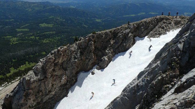
The Great One.
From Pomp we hiked back down to the pass and then followed the trail up to Sacajawea. Not far below the summit we encountered the goats, who are fairly accustomed to having plenty of two-legged visitors. As we were watching them, we chatted with a fellow who had packed his skis up – We’d seen several others who were doing the same. He told us they climbed up in order to ski down a couloir by Naya Nuki known to local back-country skiers as “The Great One”. Mark and I decided this was something we needed to see, so after spending several minutes on the top of Sac, we followed the half-mile of ridge trail to the summit of Naya Nuki to watch. Our time on Naya Nuki was the best part of the day. The wind had died down a bit, there were plenty of goats around, and we found the perfect vantage point to watch the skiers. There are several photos of the goats and the skiers in the photo tour (see link below), including one of six skiers shooting down the couloir! – possibly the most unusual spectacle I’ve ever witnessed from a mountain-top.
The girl who ran.
Everyone knows who Sacajawea was, and I suspect that Pomp Peak is named after her son Jean Baptiste Charbonneau who was born on February 11, 1805 – Members of the Lewis & Clark Expedition called him “Little Pomp”. However, many probably don’t know that Naya Nuki was a friend of Sacajawea’s. In 1800, when Sacajawea was about 12 years old, she and several other girls (including Naya Nuki, age 11) were captured by a band of Hidatsa in a battle that resulted in the deaths of several Shoshone. Sacajawea was held captive at a Hidatsa village near present-day North Dakota until she was forced to marry Toussaint Charbonneau, and ultimately played a crucial role in the expedition – as a teenager! Sacajawea’s friend Naya Nuki, on the other hand, escaped from the Hidatsa and made a month-long 1,000-mile journey (all alone) back to her Shoshone people. If anyone deserves to have a peak named after them, Naya Nuki does!
All total.
If you were to simply hike up Sacajawea and back down the trip would be 5.5 miles round-trip with about 2,000 feet of gain, well-worth the effort to earn a spot on the highest peak in the Bridger Mountains. With our side-trips to Pomp and Naya Nuki, and our walk around the lake, Mark and I probably trekked about 7 miles with 2,700-3,000 feet of elevation gain during the 6 hours we were out. It was good exercise in a beautiful setting with good company, and Mark seemed to enjoy the sense of accomplishment that comes with scaling a peak. Situated mid-way between Helena and Billings, there’s a good chance the Bridgers have not seen the last of us.
- Photo Tour of the hike up Sacajawea, Pomp Peak, and Naya Nuki.
Best viewed on a larger screen – Be sure to read the captions. - Map of the Sacajawea Peak area.
Zoom out or in, scroll around. - Blog post about a hike along the Bridger Ridge Trail in 2017.
We started at the “M” and ended at Fairy Lake.
Below: This map marks hikes that have been featured on bigskywalker.com so far, including several in Glacier Park – Select full screen to expand, zoom in for more detail, or click on a marker for a link to the post.

Those expansive views are majestic. Love the goats! I can feel my own adrenalin kick in just looking at the skiers in the couloir. Great photos.
LikeLike