
Location, location, location . . .
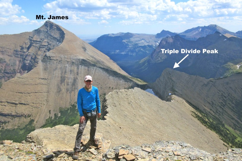
The mountains in Glacier Park are different from other mountains. Most are pyramid-shaped glacial horns that were sculpted by glaciers during past ice ages – and their color is unique too. Many rock layers in the park have an unusual reddish color that contrasts nicely with the green vegetation and persistent snowfields that often dot their slopes. However, there is one peak in the park that I’ve been interested in for several years whose appeal has little to do with its appearance, and more to do with its location. The peak’s name is Triple Divide, and what makes it extraordinary is the role it plays in dividing three major watersheds. Runoff from its east side flows into the Gulf of Mexico, the west side flows into the Pacific, and the north into the Hudson Bay. I climbed it solo in June of 2015, and again in July of 2016 with a couple friends as an excursion during a backpacking trip. (Photo Tour)
Squatching it (walking fast like Sasquatch does)
June 18-19, 2015 (solo) . . . I left on Thursday afternoon and drove to Cut Bank Campground, a quiet isolated campground exactly 200 miles from my home in Helena. I started the 7.5-mile walk to Triple Divide Pass at 6 am on Friday Morning. For the first few miles the trail passed through a forested area along the North Fork of Cut Bank Creek, then gradually climbed out of the trees along the north side of the valley, providing great views of the u-shaped valley and Medicine Grizzly Lake. I was amazed that there was no one else on the trail – I didn’t see another soul until I was almost back to the campground later that afternoon. I was squatching it, so I reached Triple Divide Pass at 9 am, traversed the east slope of the peak, and then climbed up through a gully (some class 3) to the ridge on the south side of the summit. I reached the top at 9:30 am.
The runt of the litter
You might think a mountain with such huge responsibility would tower over the landscape – not so. In fact Triple Divide is surrounded by taller peaks in every direction. I knew this going in, and was hoping to climb one of them if time allowed – ether Norris Mountain to the northwest, or Mt. James to the northeast. After spending time admiring the three valleys, trying to identify distant peaks, and surveying the ascents to James and Norris, I decided to climb Mt. James. Norris was intimidating! – Plus, I hadn’t researched safe routes to its summit. James on the other hand looked to be a simple steep hike to the top – which it was. As much as I enjoyed the views from Triple Divide Peak, the vantage point from the top of Norris was even better. From there I could see much of the park, look down on Triple Divide, and gaze out over the expansive prairie of north-central Montana.
I only hike when I am with someone or alone.
July 29, 2016 (One year later) . . . I returned to Triple Divide Peak with a couple friends (Murray and Greg) during a 3-day, 2-night backpacking trip. The three of us climbed Triple Divide on a side-trip as we journeyed from our campsite at Atlantic Creek to our next campsite at Red Eagle Lake. There was less snow this time, so we took a different (and safer) traverse route across the east face of Triple Divide Peak AND we climbed Norris Mountain as well! It was one of the best days of hiking I’ve ever had. Take a look through the photo tour to see photos from both trips to Triple Divide and beyond, and be sure to read the captions.
Difficulty
To hike from Cut Bank Campground to the top of Triple Divide Peak and back is 16 to 17 miles with 2,900 ft. of elevations gain. I rate that as “difficult” (on my personal scale). If you were to include a hike to the summit of Mt. James, the hike becomes an 18-miler with 4,900 ft. of elevation gain. For me (age 57) that is “extreme”. If you were to include Norris (but not James), it would be even more extreme due to the amount of class 3 climbing required.
Links – Check these out!
- Photo Tour
Photos on, above, and around Triple Divide Peak. - Map of Triple Divide Area
Zoom in or out, etc. - Cut Bank Campground
Less than an hour NW of Browning - Climb Glacier National Park – By Blake Passmore
Four Excellent climbing guides for peaks in the park.
Volume #5 is coming out next spring. - Glacier Mountaineering Society
These folks have a lot of fun.
FYI
1. According to Cedron Jones, author of Peakbagging Montana, there are 70 peaks in the Montana over 11,000 feet, and all of them are in the southwest quadrant of the state. In fact there are only six peaks NOT in the SW quadrant that are over 10,000 feet, and all six are in Glacier Park.
2. A divide is an imaginary line that separates watersheds. Divides aren’t always ridges and peaks, and they aren’t always the highest terrain in the area. Of course the Continental Divide (aka “The Great Divide”) is the most famous of all divides.
3. A watershed (aka drainage basin) is all the land that sends its runoff into a particular river (or body of water). The watershed of the Mississippi covers over half of the “lower 48”. The watershed of the Missouri is part of the Mississippi’s watershed, and all the land Montana west of the Continental Divide is part of the Clark Fork Watershed, which is part of the Columbia River Watershed.
4. Technically, the Hudson Bay and the Gulf of Mexico are both parts of the Atlantic Ocean, so melt-water from the three sides of Triple Divide Peak will end up in two different oceans. There is a peak in Canada named “Snow Dome” where one slope flows into the Pacific, one slope into the Arctic Ocean, and another into the Atlantic (via the Hudson Bay).
5. Unlike Yosemite Park, you won’t see technical rock-climbers in Glacier Park. Yosemite is made almost entirely of granite, whereas the mountains of Glacier consist of layers sedimentary rock (actually meta-sedimentary), many of which fall apart too easily for rock-climbers to depend on.
6. Cut Bank Campground (not to be confused with the town of Cut Bank) had 13,000 visitors during the summer of 2016 compared to over 357,000 at Many Glacier.
Below: This map marks hikes that have been featured on bigskywalker.com so far, including several in Glacier Park – Select full screen to expand, zoom in for more detail, or click on a marker for a link to the post.

Very cool! This hike is high on my list when I return to Glacier.
Also, hello from a fellow Montanan 😊😊
LikeLike
I’m a novice hiker as I’m from Northeast South Dakota and we have only flatland here. I’d like to do the “Squatching it” hike as you explained it. Is this reasonable for me by myself? I’ve done a 6 mile round trip 1600 ft climb in 2 hours. I’m concerned about how easy the trail is to follow, etc. Any info you have would be greatly appreciated.
Thanks,
Rob
LikeLike
Rob,
You might be able to do it, but based on the information you’ve given me, I would not recommend it for you. There is a nice trail to Triple Divide Pass, but then it gets difficult. You should try some 15-mile hikes (with significant elevation gain) in a safe place before you try this one. If you look through the photo tour and read the captions, you will find lots of information about the route, etc. Ultimately you will have to decide it you can do it. -Rod
LikeLike
Great photos — I need to make it back up there one of these years, choss or not. I’ve been to the Columbia Icefield, but I didn’t realize there was another triple divide in Glacier, and am surprised it is such a minor bump.
LikeLike
Nice! thanks
Jim, Canberra
LikeLike