
Of the six peaks in Glacier Park taller than 10,000 feet, Mount Siyeh is the one that I was most interested in climbing – maybe because I saw so much of it as I did other hikes in the Many Glacier area. I was especially impressed as I gazed up its 4,000-ft. vertical north face during a hike to Cracker Lake, and had been wowed by photos I’d seen of Cracker Lake taken from the top of Siyeh. I knew that non-technical climbers (including some of my students) had climbed it, but it seemed REALLY steep no matter which side I viewed it from. Quite frankly, I was a bit intimidated.
He had me at “Siyeh”.
For me, the preferred way to climb a peak that is “out of my comfort zone” is to go with a trusted friend who has already climbed the peak. My friend John and I don’t do many adventures together, but when he calls I’m always interested. He has hiked over 1500 miles and climbed 45 peaks in Glacier Park, and currently he’s into doing long scenic alpine traverses that I absolutely enjoy. So when John called to propose a 17-mile trek from Many Glacier to Siyeh Bend that included summiting Mt. Siyeh, my immediate response was, “I’m in.” (Photo Tour)
What goes up must come down.
My daughter and two of John’s friends joined us on this trek. We departed from Lake McDonald at 5:30 am, drove up and over Logan Pass, left one car at the parking area at Siyeh Bend, continued to Many Glacier, and started hiking at 7 am. We followed the Cracker Lake trail for a couple miles before going off-trail and ascending the steep rocky slope to Mt. Wynn. The photo tour will take you through the journey, which some call the “Skyline Experience” because of the 5.5-mile stretch that makes you feel like you’re walking on top of the park. It might be the most enjoyable day-hike I’ve ever done, and one of the most difficult as well. There were several challenges that John guided us through, but the most dangerous of these was the descent from Mt. Siyeh to Preston Park. As you will see in the photo tour, this is where you really need to know what you’re doing – choosing the wrong route could put you in deep trouble. The hike ended up being about 17 miles with over 7,000 feet of elevation gain. We walked the last two miles with our headlamps on, reaching Siyeh Bend at 9:45 pm.
Don’t have a friend like John?
As far as logistics go, the biggest inconvenience was the shuttle. We all stayed in cabins on Lake McDonald the night before and after the hike. The morning after the hike, Amy and I gave John a lift over to Many Glacier to retrieve his car, we enjoyed breakfast together at a restaurant in St. Mary, and then all headed back to Helena. If you want to hike the Skyline, or climb Siyeh from a shorter approach (still very difficult), you’ll need to do some research first. There are a few links below that will direct you to some good resources – photos, websites, books, maps. We did our hike on August 20th, so we didn’t have to worry walking across snow on steep slopes, which could be a problem in June and July. Be fit, and be careful!
- Photo Tour of the Skyline – Really good photos!
An extremely difficult, extremely rewarding day hike. - Interactive Topo Map of the Area
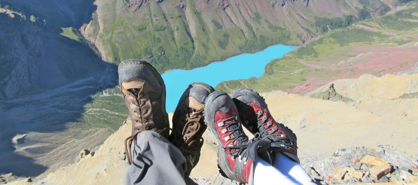
Zoom in or out. - More about that blue color of Cracker Lake
A great example of “glacial milk.” - A detailed account of the Skyline Experience
Summitpost.org page with much more info about the hike. - A Climber’s Guide to Glacier Park – by J. Gordan Edwards
Includes a description of the Skyline route. - Climb Glacier Park National Park: Vol. I – by Blake Passmore
How to climb Mt. Siyeh (not the Skyline) – great photos. - Hike 734’s Blog Post about Climbing Siyeh
Includes a YouTube video.
Below: This map marks hikes that have been featured on bigskywalker.com so far – Select full screen to expand, zoom in for more detail, or click on a marker for a link to the post.

Wow! The photos take my breath away. I get vertigo easily, and your photo tour just took me to the top of Mt Siyeh.
I worked a summer in Glacier Park as the laundry truck driver in the 1980s. Being young and restless, I climbed many peaks on my free days. The Garden Wall and Chief Mountain are two hikes that always stick in my mind, due to the exposure I was in. Heights bother me. But just the name of “Mt Siyeh” gave me the willies and it was one mountain I did not want to try and climb.
Now I feel like I have done it, sort of. Must have been a long day. Thanks Bigskywalker.
LikeLike
It was indeed a long day, but it was a GREAT day. I’m usually not afraid of heights, but being on the edge of Siyeh bothered me as well – That 4,000 foot cliff on the north face is something to behold!
LikeLike
I should also mention, for those who may be thinking about doing this hike . . . Since I posted it, a couple different people have told me that they encountered grizzlies on the slopes of Siyeh in August- Occasionally they go up there to eat moths. We didn’t see any when were up there on August 20, 2016.
LikeLike
I can see why this was your favourite day hike of all time. Your photo gallery is amazing. It really does feel like you’re on top of the world. I may have told you that we have a trip to Glacier planned in early September (first time and very excited). This hike is beyond our skill/endurance level but we hope to do lots of hiking in the Many Glacier and Logan Pass areas.
LikeLiked by 1 person
There are some wonderful hikes in those two areas. The nice thing about Many Glacier is that you can camp there, AND it is the trailhead for some great day-hikes, including Grinnell Glacier, Ice Berg Lake, Ptarmigan Tunnel, and Cracker Lake (listed in order of preference). Ice Berg Lake and Ptarmigan Tunnel can be done on the same day. Have fun!
LikeLiked by 1 person
Great. Thanks for the info. We selected Many Glaciers for that reason…being right at several trailheads.
LikeLike