
“Let’s play two!” –Ernie Banks
This past Saturday (5/27/17), some friends and I left Helena at 6 am, drove 140 miles to Lost Lake (via Great Falls and Highwood), walked along the cliffs on the north side of the lake, and then drove over to make the challenging climb onto Square Butte – about 30 miles down the road from Lost Lake. (Photo Tour)
Did Charlie know?
Fifty million years before Charlie Russell painted scenes of central Montana, a volcano dominated the landscape east of Great Falls – The Highwood Mountains are the eroded remains of this ancient volcano. In fact, many of the buttes and mountains that form the backdrop in Russell’s paintings were formed by ancient volcanic activity. Pressure beneath the volcano fractured surrounding bedrock, and then magma moved into the cracks or between layers of sedimentary rock, hardening beneath the surface. The rocks that make up Square Butte and the cliffs that surround Lost Lake formed this way (underground), and then were uncovered by millions of years of erosion. Square Butte is visible from miles away, whereas Lost Lake can’t be seen until you’re practically on top of it.
IMPORTANT UPDATE: As of May 2020, Lost Lake is now closed to the public due to the high volume of visitors, litter, and graffiti.
The big spill.
A sign along Lost Lake Road 18 miles west of Highwood tells where to park, and states, “hike at your own risk.” From there it is less than half a mile to the lake where a trail winds through the cliffs on the northwest side. The path provides great views of a strange, beautiful place with a fascinating geologic past – one that that involved an unusual set of circumstances during the last ice age. As the continental glacier grew southward into this area, the ice pinched up against the north slope of the Highwood Mountains (~15,000 years ago), blocking the flow of the ancient Missouri River, and causing the formation of Glacial Lake Great Falls. The lake grew deeper and eventually burst through the blockage near the town of Highwood – an outburst flood occurred. As the glacier advanced and retreated, the lake drained and reformed many times. The path and intensity of the overflow varied, but the most distinct channel remaining today is called “The Shonkin Sag”. Although not part of the Sag, the lake was formed by a tremendous stream of water that included 250-ft. waterfalls on its west end, proving that flood-waters from Lake Great Falls occasionally cut across there.
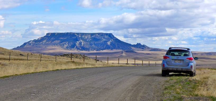
I like big buttes, and I cannot lie.
After exploring Lost Lake, we drove over to Square Butte and started our hike to the top at 10:40 am. Although Square Butte is on public land, it is surrounded by private property, so I called ahead for permission. We drove through a ranch, followed a rough Jeep trail for a couple miles, and then walked across the prairie toward a notch on the east side of the butte. Once through the notch we bushwhacked up the steep forested slope to the cliffs – about 2 hours to reach the top. To learn more about our route, including where NOT to walk, look through the photo tour. The photo captions explain more about the geology of Square Butte as well. The animation (see link below) is another excellent source for those interested in seeing how the butte formed.
One important caution – Watch out for rattlesnakes! Two of my buddies almost stepped on a couple as we were walking through the grassy area near the base of the butte.
FYI, links, etc.
- Photo Tour
It was a perfect, sunny day for photographing Lost Lake and Square Butte. - More about the Shonkin Sag
Caused by a strange situation during the last ice age. - Animation that shows how laccoliths form – Very good!
This 3-step animation shows how Square Butte and other intrusive (plutonic) formations form. Be sure to select, “Labels on”. - More about Glacial Lake Great Falls
Wikipedia - Article about Lost Lake from Distinctly Montana
Includes more photos of this hidden gem. - More about Lost Lake
More about the geology of this ice age waterfall. - Charlie Russell (1864-1926)
CM Russell was a great western artist that lived in Great Falls – Central Montana is sometimes referred to as “Russell Country.” - When the Land Belonged to God
This Russell masterpiece includes three features associated with the ancient volcano. Look on the horizon to the right of the bison to see Square Butte, Round Butte, and the Highwoods. - There are 11 buttes in Montana named “Square Butte”. The two most iconic ones are the one 22 miles west of Great Falls (visible from some parts of Great Falls), and the one featured in this post, which is 50 miles east of Great Falls. Lewis and Clark called the one west of Great Falls “Fort Mountain” and they referred to the one east of Great Falls as “Barn Mountain.”
Below: This map marks hikes that have been featured on bigskywalker.com so far – Select full screen to expand, zoom in for more detail, or click on a marker for a link to the post.

Your photos are amazing. The lake surrounded by the cliffs is just stunning. You sure have lots of treasures in Montana
LikeLiked by 1 person
Nice article and photos. Thanks.
LikeLike
Very cool, I hiked that butte a few times myself, grew up in Stanford, Montana,[South of square butte, and round bute]
LikeLike