
A Helena place to hike.
My favorite thing about living in Helena is having access to over 75 miles of trails that border the southern edge of town. The trail system came about as the result of a partnership between the Prickly Pear Land Trust, the City of Helena, and the Forest Service. We Helenans love our trails! My favorite starting points are the Beattie Street and Mt. Helena Trailheads – Both are less than a 10 minute drive from my house and both provide access to trails that lead to mountains over-looking the Capital City. Like many local hikers, bikers, and runners, I enjoy the trails year-round, even during winter. Almost every weeknight I load up the dogs, put a headlamp on, and go for a hike after dark. We can leave the house at 7 pm, do a 3-4 mile hike and be home by 8:30 or 9 o’clock. Its good therapy, helps keep me in shape for my occasional snowshoe adventures, and the dogs love it! On weekends its fun to get out in the morning – Saturday mornings are the best.
A matter of perspective.
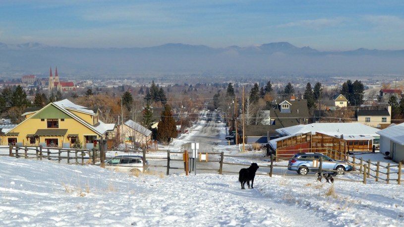
This past weekend was especially interesting because there was a temperature inversion in the Helena Valley. These occur several times every winter in our bowl-shaped valley, sometimes lasting for several days and causing bad air quality as the cold stagnant air fills with pollution. But from a hikers perspective, I actually like getting out on inversion days – They are sunny and calm, and its a visual treat to look down on them from Mt. Ascension or Mt. Helena. Check out the Photo Tour to see what I mean.
Its a valley thing.
During winter months, the mountain valleys of western Montana are prone to inversions – called this because they really are “upside-down” situations. NORMALLY the atmosphere gets colder as you get farther away from Earth’s surface because the air is warmed from the bottom up by heat given off by the Earth. However during inversions, air at the surface is much colder than the air above. Local hikers know this means that it can be 5-10 degrees warmer on top of the mountain than it is down at the trailhead.
Recipe for a temperature inversion – The three C’s
Mountain valleys serve as “sinks” where cold, dense air may sit for several days. They develop during clear, calm, cold nights – especially in December and January. Clouds act like a blanket, keeping much of the heat given off by the Earth close to the surface. However, on clear nights this heat escapes quickly out to space, and air at the surface becomes cold (and heavy). The low angle of the Sun in December and January prevents this valley air from heating up during the day. Snow cover, which reflects sunlight, and short winter days also help prevent it from warming. If the inversion persists for several days, air quality worsens as the stagnant, cold air fills with pollutants such as smoke from wood-burning stoves or emissions from automobiles. Eventually wind associated with a storm will pass through and push the polluted air out. In the meantime, my strategy is to head for the South Hills and hike up to where the air is clear and the views are interesting.
This post is dedicated to Wes Lambert (1930-2017). Wes, who enjoyed learning right up to the end, was one of my most faithful readers. Thanks for the encouragement, Wes. Rest in peace.
- Photo Tour.
Two morning hikes above the first inversion of December 2017. - Map of the Helena South Hills Trails – Zoom in or Scroll Around.
Mt. Helena and Mt. Ascension are city parks. - Vimeo Video
One-minute video of the Helena Valley temperature inversion. - Prickly Pear Land Trust.
This is a great organization! - Map of the 2006 Trail.
My favorite way to get up Mt. Ascension.
Below: This map marks hikes that have been featured on bigskywalker.com so far – Select full screen to expand, zoom in for more detail, or click on a marker for a link to the post.

You live in a beautiful place. It’s wonderful having access to all those trails.
LikeLiked by 1 person